Solutions-NCERT-Class-7-Social Science-Part : 1-Chapter-3-Climates of India-CBSE

Climates of India

NCERT-Class-7-Social Science-Part : 1-Chapter-3-CBSE

Solutions (Exercise + Intext)

The Big Questions :

Question 1. What makes India’s climate so diverse?

Answer :

India's climate is diverse because of several geographical and environmental factors. These include:

  • Latitude – Places near the Equator are warmer, while northern regions are cooler.
  • Altitude – Higher areas, such as mountains and hill stations, are cooler than the plains.
  • Distance from the Sea – Coastal areas have moderate temperatures, while inland areas experience more extreme heat and cold.
  • Winds – Winds bring heat, cold, and rainfall to different regions.
  • Topography – Features like the Himalayas and the Western Ghats influence temperature and rainfall patterns.

Because of these factors, India experiences a variety of climates, ranging from cold alpine regions and hot deserts to tropical coastal areas.

Question 2. What are the monsoons? How are they formed?

Answer :

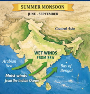
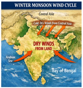
The monsoon is a system of seasonal winds caused by differences in the heating and cooling of land and ocean.

How they are formed : They are formed based on the principle that land heats up and cools down faster than the ocean:

  • Summer (Southwest) Monsoon: As summer begins, the Asian landmass heats up, creating a low-pressure system. Cooler, high-pressure air from the ocean blows toward the land, carrying moisture that falls as heavy rain.
  • Winter (Northeast) Monsoon: In winter, the pattern reverses. The land cools rapidly, creating a high-pressure system that blows dry air toward the warmer, lower-pressure ocean. However, these winds can pick up moisture over the Bay of Bengal to bring rain to parts of eastern and southern India.

Question 3. What is the effect of climate on economy, culture and society?

Answer :

Climate affects many aspects of life in India.

  • Economy : India's economy depends greatly on weather, especially the monsoon. Poor rainfall can lead to crop failure, water shortages, higher food prices, and migration of farmers and labourers to cities.
  • Culture : The lives of people in India are closely linked to the six traditional seasons (ṛitus). These seasons influence the crops grown, the food people eat, and the clothes they wear.
  • Society : Many Indian festivals such as Bihu, Pongal, Onam, and Baisakhi are linked to farming and seasonal changes. Climate also influences Indian classical music, with ragas such as Megh Malhar being inspired by the monsoon season.

Question 4. How can understanding the climate help us to prepare for natural disasters?

Answer :

Understanding climate patterns allows for better prediction and resilience against disasters like cyclones, floods, landslides, and forest fires:

  • Prediction: The India Meteorological Department (IMD) tracks the formation and path of cyclones to provide early warnings.
  • Identifying Causes: Understanding how human actions—like deforestation or blocking natural waterways with concrete—worsen floods and landslides helps in planning safer infrastructure.
  • Resilience: Knowledge of climate-related risks supports the training of specialized groups like the National Disaster Response Force (NDRF) to conduct efficient rescue and evacuation.

Question 5. What is climate change? What are its consequences?

Answer :

Climate change refers to significant, long-term shifts in global or regional climate patterns. While natural processes once drove these shifts, since the 19th century, it has been primarily caused by human activities such as burning fossil fuels and deforestation.

Consequences include:

  • Global Warming: The release of "greenhouse gases" traps extra heat in the atmosphere.
  • Shifting Seasons: India has seen rising temperatures resulting in shorter, milder winters, which disrupts agricultural production.
  • Extreme Weather: Increased melting of glaciers can lead to devastating glacial bursts and floods, as seen in Uttarakhand in 2013.
  • Socioeconomic Strain: Changes in predictable weather patterns present increasing challenges for food security and industrial activity.

Intext/Textbook Exercises :

Let's Explore :

Question 1. Which are your favorite seasons? Write a short essay explaining your reasons.

Answer :

India experiences different seasons throughout the year. My favourite seasons are spring and autumn because the weather during these seasons is pleasant and comfortable.

Spring comes after winter. The days become warmer, flowers bloom, and trees grow fresh green leaves. The surroundings look colourful and beautiful. The weather is neither too hot nor too cold, which makes outdoor activities enjoyable.

Autumn comes after the rainy season. The sky becomes clear, the air feels fresh, and the weather is cool and pleasant. It is a beautiful season with bright sunshine and comfortable temperatures. Many important festivals are also celebrated during this time.

I like spring and autumn because they are peaceful, refreshing, and enjoyable. These seasons make nature look beautiful and allow people to spend more time outdoors. Therefore, spring and autumn are my favourite seasons in India.

Question 2. Do you know which trees in your area change colours before the onset of winter? Are there trees that shed their leaves around this time? Why do you think this happens?

Answer :

Yes. In and around my area, many trees show seasonal changes before winter, although the effect is usually less dramatic than in colder countries.

Some common trees around my area whose leaves may turn yellow, golden, reddish, or brown before falling include:

  • Teak (Sagwan) – leaves often turn yellow or brown before shedding.
  • Indian Almond – one of the few trees that can show bright red, orange, and yellow leaves.
  • Flame of the Forest (Palash) – leaves dry and fall before flowering.
  • Neem – sheds many old leaves, which may turn yellow first.
  • Banyan and Peepal – may lose some leaves seasonally and produce new leaves soon after.

Trees That Shed Their Leaves

Yes. Many trees in my area are deciduous, meaning they shed their leaves during the dry season (often from late autumn to early spring). Examples include:

  • Teak
  • Palash
  • Neem
  • Indian Laburnum (Amaltas)
  • Indian Almond

Why Does This Happen?

Trees shed their leaves mainly to:

  1. Save water during the dry season. Leaves lose water through transpiration, so dropping them helps the tree conserve moisture.
  2. Prepare for new growth. Old leaves are replaced by fresh leaves when conditions become favourable.
  3. Reduce stress caused by cooler temperatures and lower availability of water.

Question 3. Udhagamandalam (Ooty) and Colmbatore are almost at the same altitude. The range of summer temperatures in Ooty is 10 - 25 while that in Coimbatore is 25 - 38. Why do you think there is such a difference in temperature between these two places?

Answer :

  • The difference in temperature between Ooty and Coimbatore is mainly due to altitude, not latitude. Both places are almost at the same distance from the Equator, but Ooty is located much higher above sea level than Coimbatore.
  • As altitude increases, the temperature decreases because the air becomes thinner and cooler. Also, places at higher elevations are farther from the Earth's surface, which is heated by the Sun.
  • Therefore, Ooty, being a hill station, has a much cooler climate, while Coimbatore, which is located in the plains, experiences higher temperatures. This is why many people visit Ooty to enjoy its pleasant weather and escape the heat of the plains.

Question 4. Since the ability to predict the monsoon rainfall has been an important aspect of life in India, our ancestors observed Nature around them carefully. They developed local traditional knowledge through their experience. This traditional knowledge is an Important heritage we must preserve. For example, fishermen on the Konkan coast predict the onset of the monsoon when fishes that normally stay under water are seen at the surface; In parts of southern India monsoon is said to arrive within 50 days after the Golden Shower tree (Cassia fistula) blossoms. Some communities also believe that when crows build their nests high on tree-tops, It indicates less rainfall, whereas If the nests are lower, rainfall is likely to be heavy. Make a list of such local knowledge about rain, fog, snow or hail in your area.

Answer :

People have observed signs in nature for centuries to predict rain. Some common indicators are:

  • Dark Clouds – Thick, dark clouds gathering in the sky often indicate rain.
  • Cool Winds – A sudden cool breeze may signal approaching rain.
  • High Humidity – The air feels moist and sticky before rainfall.
  • Frogs Croaking Loudly – Frogs become more active before rain.
  • Ants Moving in Lines – Ants may carry food and move to higher ground before rain.
  • Birds Flying Low – Birds often fly closer to the ground when rain is approaching.
  • Peacocks Dancing – Peacocks are often seen spreading their feathers and dancing before rain.
  • Dragonflies Flying Low – Dragonflies may fly near the ground before rainfall.
  • Strong Smell from the Soil – A pleasant earthy smell can be noticed when rain is about to fall.
  • Halo Around the Moon or Sun – A ring around the Moon or Sun may indicate rain in the near future.
  • Bees Returning to Their Hives – Bees often seek shelter before bad weather.
  • Leaves Turning Upwards – Some plants and trees show changes in their leaves before rain.

These natural signs are not always accurate, but they have been used by farmers and local communities for generations to predict rainfall.

Question 5. Have you seen or read about floods? Look at the physical map of India. Discuss in pairs why you think floods occur in the areas mentioned above.

Answer :

Yes, I have read about floods and seen pictures of them. Floods can cause severe damage to homes, roads, crops, and property.

I looked at the physical map of India and discussed with my friend why floods occur in states like Uttar Pradesh, Bihar, Kerala, Andhra Pradesh, and Assam.

  • Uttar Pradesh and Bihar: Large rivers such as the Ganga and its tributaries flow through these states. During the monsoon, heavy rainfall causes the rivers to overflow. Since these regions are mostly flat, floodwater spreads over large areas.
  • Kerala: Kerala receives very heavy rainfall during the monsoon season. It has many rivers and is located close to the sea. Excessive rainfall and overflowing rivers often lead to floods.
  • Andhra Pradesh: This state lies along the eastern coast of India. Cyclones from the Bay of Bengal often bring heavy rainfall, causing rivers to overflow and resulting in floods.
  • Assam: The mighty Brahmaputra River flows through Assam. Heavy monsoon rains and water flowing down from the surrounding hills often cause the river to overflow, leading to frequent floods.

Question 6. Observe Fig. 3.15. Describe the effects they may have on people, plants, animals and economic life.

Answer :

Figure 3.15 illustrates four major climate-related disasters: landslides, floods, cyclones, and forest fires. These events have wide-ranging and often devastating consequences across various aspects of life:

Effects of Natural Disasters

  1. Effects on People :
  • Loss of human lives.
  • Destruction of homes and property.
  • People may have to leave their homes and migrate for work.
  • Poor air quality can affect health.
  1. Effects on Plants :
  • Forests and vegetation may be destroyed.
  • Trees can be uprooted.
  • Soil erosion and damage to ecosystems can occur.
  1. Effects on Animals :
  • Animals may be injured or killed.
  • Natural habitats can be destroyed.
  • Animals may lose food and shelter.
  1. Effects on Economic Life :
  • Crops and livestock may be affected.
  • Roads, bridges, and buildings can be damaged.
  • Food prices may increase.
  • Local and national economies may suffer losses.

Let's Remember :

Question 1. We studied about latitudes in Grade 6. Do you remember that latitudes measure the distance from the Equator, increasing as we move away from It (either Northward or Southward)? While the climate around the Equator is extremely hot, as the latitude increases it becomes temperate and then cold or frigid. Why is this so?

Answer :

Yes I do remember.

As we move away from the Equator, the Sun's rays strike the Earth at a lower angle.

Near the Equator, the Sun's rays are direct and concentrated, so temperatures are higher. At higher latitudes, the rays spread over a larger area and become less intense. They also pass through a thicker layer of the atmosphere, which reduces their heating effect.

As a result, places farther from the Equator have cooler climates than places near the Equator.

Questions and activities :

Question 1. Match the climatic factors with their effects:

Column A Column B
(1) Latitude (a) Brings wet air to India during summer
(2) Altitude (b) Creates different climates in the north and south
(3) Proximity to the ocean (c) Keeps higher places cooler
(4) Monsoon winds (d) Moderates the temperature

Answer :

Column A (Factor) Column B (Effect)
(1) Latitude (b) Creates different climates in the north and south
(2) Altitude (c) Keeps higher places cooler
(3) Proximity to the ocean (d) Moderates the temperature
(4) Monsoon winds (a) Brings wet air to India during summer

Question 2. Answer the following questions:

(a) What is the difference between weather and climate?

Answer :

  • Weather refers to the short-term conditions we experience every hour or day, such as rain, bright sunshine, or wind. It is constantly changing.
  • Climate is the long-term pattern of weather that a region experiences over a period of at least several decades.

(b) Why do places near the ocean have milder temperatures than places far away from it?

Answer :

The sea acts as a moderator for temperature because land and water heat up and cool down at different rates.

  • Land absorbs and loses heat quickly.
  • The sea absorbs and loses heat slowly.
  • In the summer, coastal regions are cooled by sea air, while in the winter, they are warmed by sea air. This results in a smaller "range of temperature" (the difference between maximum and minimum) compared to inland areas like Nagpur, which experience more extreme heat and cold.

(c) What role do monsoon winds play in affecting India’s climate?

Answer :

Monsoon winds are seasonal winds that dictate the timing of rainfall and seasonal transitions in India.

  • Summer (Southwest) Monsoon: These winds blow from the cooler, high-pressure ocean toward the hot, low-pressure land, carrying moisture that falls as heavy rain across the subcontinent.
  • Winter (Northeast) Monsoon: The pattern reverses, and dry winds blow from the land toward the ocean. However, as they pass over the Bay of Bengal, they pick up moisture and bring rainfall to parts of eastern and southern India.
  • Economic & Cultural Impact: These winds are vital for agriculture, influencing crop cycles, livelihoods, and many regional festivals.

(d) Why is Chennai warm or hot throughout the year, while Leh is cold?

Answer :

This difference is caused by both latitude and altitude:

  • Latitude: Chennai is at a much lower latitude, closer to the Equator. Places near the Equator receive more concentrated energy from the sun's rays and are warmer year-round.
  • Altitude: Leh is located at a very high altitude in the Himalayan region. The sources explain that temperature decreases as altitude increases because the air becomes less dense and is further away from the Earth's surface, which the sun heats first. Additionally, northern places at higher latitudes, like Leh, receive less heat because the sun's rays hit the area at an oblique angle.

Question 3. Look at a map of India given at the end of this book. Identify the climate for these cities — Leh, Chennai, Delhi, Panaji and Jaipur. 

  • Is the place near the sea, in the mountains, or in the desert?
  • How do these factors affect the climate there?
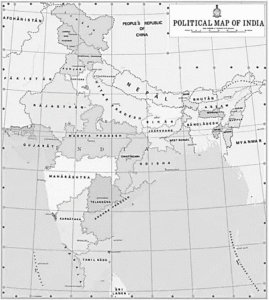
Answer :

(1) Leh :

  • Location: In the mountains (Himalayas).
  • Climate Type:
  • Factors and Effects: Leh’s climate is primarily determined by its high altitude and northern latitude. Because temperature decreases as altitude increases, Leh experiences a very cold climate with snowy winters and cool summers. Being at a higher latitude (further from the Equator) also means it receives less concentrated solar energy, contributing to its cold environment.

(2) Chennai :

  • Location: Near the sea (coastal).
  • Climate Type:
  • Factors and Effects: Chennai is at a low latitude, close to the Equator, which keeps it warm or hot throughout the year. However, its proximity to the sea acts as a moderator; the sea absorbs and loses heat slowly, preventing the temperature from reaching the extremes seen inland. Its wet and dry periods are heavily influenced by the monsoon winds.

(3) Delhi :

  • Location: In the northern plains, far from the sea.
  • Climate Type:
  • Factors and Effects: Because it is located inland and away from the moderating influence of the ocean, Delhi experiences extreme temperatures—very hot summers and cold winters. During the summer, it is prone to severe heat waves caused by hot, dry winds blowing from the west, while in winter, it receives cold winds from the Himalayas.

(4) Panaji :

  • Location: Near the sea (western coastal strip).
  • Climate Type: Tropical wet.
  • Factors and Effects: Similar to Chennai, its coastal location means the sea moderates its temperature, resulting in a smaller temperature range. Because it is on the western coast, it receives heavy rainfall during the southwest monsoon months, as the Western Ghats act as a topographical barrier that triggers precipitation.

(5) Jaipur :

  • Location: In/near the desert (Thar Desert).
  • Climate Type:
  • Factors and Effects: The topography of this region is relatively flat, offering no protection from hot and dry winds. This results in a climate characterized by extremely hot days, cool nights, and very little rainfall. Like Delhi, its distance from the sea leads to more extreme temperature variations compared to coastal cities.

Question 4. Draw the monsoon cycle in summers and winters on a map of India.

  • Label where the winds blow in summer and winter
  • Show the direction of winds during the monsoon

Answer :

Question 5. Make a colourful poster showing festivals in India linked to farming and weather (e.g., Baisakhi, Onam). Add pictures or drawings of these festivals.

Answer :

Student should do it by self

Question 6. Imagine you are a farmer in India. Write a short diary entry about how you would prepare for the rainy season.

Answer :

June 1, 2026

This summer has been very hot. Today, I saw the Golden Shower tree covered with yellow flowers. My elders say this means the rainy season will arrive soon. I also noticed that crows are building their nests lower in the trees, which may mean there will be heavy rain.

I have started preparing my fields for the monsoon. Today, I ploughed the fields and removed weeds so that the soil is ready for sowing seeds. I also cleaned the irrigation channels and checked the storage area for seeds and fertilizers.

I have started repairing the fences around the farm to protect the crops from animals. I hope the monsoon arrives on time and brings enough rain for a good harvest. Like every year, I am looking forward to a successful farming season.

Farmer

Question 7. Identify a natural disaster (e.g., cyclone, flood, landslide, or forest fire) and write a short essay that includes the causes and impacts. Suggest actions that individuals, communities and the government can take to reduce the impact.

Answer :

Floods: Causes, Impacts and Prevention

Floods are one of the most common natural disasters. They occur when excess water covers land that is normally dry. Heavy rainfall, overflowing rivers, cyclones, and poor drainage systems are some major causes of floods. Human activities such as deforestation and construction on riverbanks can also increase the risk of flooding.

Floods can cause great damage to life and property. Houses, roads, and crops may be destroyed. People may lose their homes and livelihoods. Floods can also spread diseases by contaminating drinking water.

To reduce the impact of floods, individuals should avoid throwing waste into drains and follow weather warnings. Communities can keep drainage systems clean, plant more trees, and participate in disaster preparedness programs. The government can build strong flood-control structures, improve drainage systems, provide early warning systems, and enforce proper land-use planning.

By working together, individuals, communities, and the government can reduce the damage caused by floods and protect lives and property.

Rs 10 ncert 8

-Kitabcd Academy Offer-

Buy Notes(Rs.5)+ Exam Master (Rs.7) - (2 PDF) of this chapter
Price : Rs.12 / Rs.10

Click on below button to buy PDF in discounted price

Key Features of Kitabcd Exam Master :

  • NCERT Probe and Ponder/Intext Questions with Solutions,
  • Keep the Curiosity Alive/Exercise Questions with Solutions.
  • Objective Type Questions with Answers (MCQ, Fill in blanks, True or False)
  • Activities with answers.
  • Exam Oriented Questions and Answers
  • Case/Source Based Questions
PDF Links

Click on below links to get PDF from store

PDF : Class-7-Social Science-Part : 1-Chapter-3-Climates of IndiaNotes

PDF : Class-7-Social Science-Part : 1-Chapter-3-Climates of IndiaExam Master (Solutions)

Useful Links

Main Page : NCERT-Class-7- Social Science (Part-1) All chapters notes, solutions, videos, test, pdf.

Previous Chapter : Chapter-2- Understanding the Weather Online Solutions

Next Chapter : Chapter-4- New Beginnings: Cities and States Online Solutions

Leave a Reply

Write your suggestions, questions in comment box

Your email address will not be published. Required fields are marked *

We reply to valid query.