Notes
Introduction :
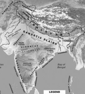
India – Location and Regions :
- India is the seventh-largest country in the world.
- It is located in the continent of Asia.
- India and its neighbours — Pakistan, Bangladesh, Nepal, Bhutan, Sri Lanka, and Myanmar — together form the Indian Subcontinent.
- It is called a subcontinent because it is a large part of Asia with distinct features.
Major Physical Regions of India :
India can be divided into five main regions.
These regions are:
- The great mountain zone (Himalayas)
- The plains of the Ganga and Indus
- The desert region
- The southern peninsula
- The islands
These regions show the diversity of India’s landforms.
Natural Boundaries of India :
- The Himalayan Mountains form a natural barrier in the north.
- The Thar Desert and the Arabian Sea lie on the western side.
- The Indian Ocean is to the south.
- The Bay of Bengal is to the east.
Importance of These Features :
- These natural features separate India from other parts of Asia.
- They have influenced India’s climate.
- They have also shaped India’s culture and history.
The Himalayas :
- The Himalayan Range is very long and looks like a huge wall on the map.
- In summer, snow melts from these mountains and forms rivers like the Ganga, Indus, and Brahmaputra.
- These rivers provide water for drinking, farming, and industries.
- Millions of people depend on these rivers for their daily life.
- Therefore, the Himalayas are called the “Water Tower of Asia.”
- The Himalayas are also sacred and important in many religions.
- Many temples and monasteries are built here.
- People from around the world come here to pray and meditate.
Formation of the Himalayas :
- Long ago, India was part of a large landmass called Gondwana.
- It later broke away and slowly moved north.
- About 50 million years ago, India collided with the Eurasian landmass.
- This collision caused the land to fold and rise, forming the Himalayas.
- This process is like a carpet wrinkling when pushed.
Growth of the Himalayas :
- India is still slowly moving north even today.
- It moves about 5 centimetres every year.
- Because of this, the Himalayas are still rising slowly.
- They grow about 5 millimetres each year.
Main Ranges of the Himalayas :
(1) Himadri (Greater Himalayas) :
- This is the highest and most rugged part of the Himalayas.
- It has very high peaks like Mount Everest and Kanchenjunga.
- The region remains covered with snow throughout the year.
- Very few people live here because conditions are harsh.
(2) Himachal (Lower Himalayas) :
- This range lies south of the Greater Himalayas.
- It has a moderate climate suitable for plants and animals.
- Many people live here.
- Famous hill stations like Nainital, Darjeeling, Shimla, and Mussoorie are located here.
(3) Shivalik Hills (Outer Himalayas) :
- These are the lowest and outermost range of the Himalayas.
- They have rolling hills and dense forests.
- The area is rich in wildlife.
- It acts as a transition zone between the Himalayas and the Northern Plains.
The Cold Desert of India :
- The word “desert” usually means a hot place.
- But India also has a cold desert.
- Ladakh is a cold desert in India.
- In winter, temperatures here fall below –30°C.
- The region gets very little rainfall.
- The land is rough with rocky mountains, deep valleys, and lakes like Pangong Tso.
Special Features of the Land :
- The land in Ladakh looks like the surface of the moon.
- So, it is called “moonland.”
- This land was formed when India collided with Eurasia.
- The area was once under an ocean.
- The rocks are mainly made of sand and clay.
- Wind and rain have shaped the mountains over time.
Wildlife and Life of People
- Even in harsh conditions, Ladakh has unique animals.
- Animals like snow leopards, ibex, and Tibetan antelopes are found here.
- The people of Ladakh live a simple life.
- The region is famous for ancient monasteries.
- Colourful festivals like Losar and Hemis Festival are celebrated here.
The Gangetic Plains :
- As we move south from the Himalayas, we reach the wide Gangetic Plains.
- These plains are very fertile and important for India.
- They have played a major role in India’s history and civilisation.
Importance of Rivers :
- These plains are fed by rivers coming from the Himalayas.
- Major rivers include the Ganga, Indus, and Brahmaputra.
- These rivers provide water for daily life.
- They also bring minerals that make the soil rich and fertile.
- This makes the region ideal for farming.
- Rivers are also used to produce electricity.
Population and Life :
- A large number of people live in the Gangetic Plains.
- The fertile land supports agriculture and livelihoods.
Transport and Trade :
- The land here is flat, which makes transport easy.
- Roads and railways are well developed in this region.
- These help in moving people and goods over long distances.
- Rivers like the Ganga and Brahmaputra have been used for travel and trade for thousands of years.
The Great Indian Desert (Thar Desert) :
- To the west of India lies the Thar Desert.
- It appears as a yellowish area on the map.
- It has vast stretches of golden sand dunes and open sky.
Formation of Sand Dunes :
- Sand dunes are formed by the action of wind.
- The wind shapes sand into hill-like structures.
- Some dunes can rise up to 150 metres high.
Climate and Region :
- The Thar Desert is a dry and arid region.
- Most of it lies in Rajasthan, Gujarat, Punjab, and Haryana.
- It has very hot days and cold nights.
- Water is very scarce in this region.
- The harsh climate acts as a natural barrier.
Life in the Desert :
- People have adapted their lifestyle to the desert conditions.
- Their food, clothing, and habits suit the environment.
- Women often travel long distances to fetch water.
Water Conservation :
- Water is used very carefully in the desert.
- Utensils are cleaned with sand and then lightly rinsed with water.
- The used water is reused for other purposes like watering plants.
- Rajasthan is famous for water-saving methods like taanka or kunds.
- These systems collect and store rainwater for daily use.
The Aravalli Hills :
- The Aravalli Hills are among the oldest mountains in the world.
- They are about 2.5 billion years old.
- The range has many peaks and ridges.
- The highest peak is Mount Abu, which is over 1700 metres high.
- Most hills in this range are between 300 and 900 metres high.
Importance of the Aravallis :
- The Aravallis play an important role in the geography of northwestern India.
- They act as a natural barrier.
- They prevent the Thar Desert from spreading towards the east.
- They also influence the climate of the region.
Minerals and Resources :
- The Aravallis are rich in minerals like marble, granite, zinc, and copper.
- Mining and construction have been carried out here for many years.
- Ancient mines at Zawar show early zinc extraction in India.
- Indians mastered zinc extraction more than 800 years ago.
Historical Importance :
- Many famous forts are located in the Aravalli Hills.
- Important forts include Chittorgarh, Kumbhalgarh, and Ranthambore.
- These forts show the historical importance of the region.
The Peninsular Plateau :
- A plateau is a raised land with a flat surface and steep sides.
- India has many plateaus, but the most important is the Peninsular Plateau.
- It is triangular in shape and lies in the middle and south of India.
- It is a very old land formation.
- It is called a peninsula because it is surrounded by water on three sides — the Arabian Sea, the Bay of Bengal, and the Indian Ocean.
Surrounding Mountain Ranges : The plateau is bordered by the Western Ghats and Eastern Ghats.
(i) Western Ghats :
- The Western Ghats are higher and run along the western coast.
- They look like a wall and have many waterfalls during the monsoon.
- They are a UNESCO World Heritage Site.
- They are rich in plants, animals, and rivers.
- The northern part is also called the Sahyadri Hills.
(ii) Eastern Ghats
- The Eastern Ghats are lower and broken into small hills.
- They lie along the eastern coast.
The Deccan Plateau :
- Between the two ghats lies the Deccan Plateau.
- It is a large area of flat highland.
Rivers of the Plateau :
- Many rivers flow across this plateau.
- Rivers like Godavari, Krishna, and Kaveri flow from west to east.
- These rivers are important for farming and water supply.
- Some rivers like Narmada and Tapti flow west into the Arabian Sea.
- These rivers also help in generating hydroelectric power.
Waterfalls :
- Many beautiful waterfalls are found on the plateau.
- They are formed because rivers flow over rocky surfaces.
- These waterfalls attract tourists.
- They also help in irrigation and electricity generation.
Resources and Importance :
- The plateau is rich in minerals, forests, and fertile land.
- It plays an important role in India’s economy.
Tribal Life
- Dense forests are home to many tribal communities.
- Tribes like Santhal, Gond, Baiga, Bhil, and Korku live here.
- They have their own languages, traditions, and lifestyles connected to nature.
India’s Amazing Coastlines :
- India has a long coastline of more than 7500 km.
- It has beautiful beaches, rocky cliffs, and green forests.
- Some beaches have golden sand, while others have black rocks.
- Some islands have coral reefs, and others have thick jungles.
- India’s coasts are very diverse and full of natural beauty.
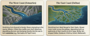
(i) The West Coast of India :
- The west coast stretches from Gujarat to Kerala.
- It passes through Maharashtra, Goa, and Karnataka.
- Rivers here start from the Western Ghats and flow quickly.
- These rivers form estuaries where they meet the sea.
- The coastline has features like coves, creeks, and estuaries.
- The Narmada and Tapti estuaries are the largest.
- This coast has many important ports and cities.
- These ports have been centres of trade and business for a long time.
(ii) The East Coast of India :
- The east coast lies between the Eastern Ghats and the Bay of Bengal.
- It stretches from the Ganga delta to Kanyakumari.
- It has wide plains and large river deltas.
- Major rivers here include Mahanadi, Godavari, Krishna, and Kaveri.
- Important water bodies like Chilika Lake and Pulicat Lake are found here.
Deltas and Their Importance :
- Deltas are formed when rivers deposit sediments at their mouths.
- They usually have a triangular or fan shape.
- Rivers like Godavari, Krishna, Kaveri, and Mahanadi form fertile deltas.
- These areas are very good for farming.
Comparison of Coastal Plains :
| Feature | West Coast | East Coast |
| Location | Between Arabian Sea and Western Ghats | Between Bay of Bengal and Eastern Ghats |
| Width | Narrow | Wider |
| Coastline Type | Submerged coastline | Emergent coastline |
| River Features | Short rivers; forms estuaries (e.g., Narmada, Tapti) | Large rivers forming deltas (e.g., Ganga, Mahanadi) |
| Port Suitability | Excellent for natural harbors | Fewer natural ports |
| States
Covered |
Gujarat, Maharashtra, Goa, Karnataka, Kerala | Tamil Nadu, Andhra Pradesh, Odisha, West Bengal |
Indian Islands :
- Indian Islands are groups of islands in the Indian Ocean, Arabian Sea, and Bay of Bengal.
- They are an important part of India’s territory.
- India has two main island groups — Lakshadweep and Andaman & Nicobar Islands.
- These islands have beautiful beaches, coral reefs, and rich wildlife.
- Some islands also have volcanoes.
- Ancient tribes have lived here for thousands of years.
(i) Lakshadweep Islands :
- Lakshadweep is a group of islands in the Arabian Sea.
- It is located near the coast of Kerala.
- It consists of 36 islands made of coral.
- Not all islands are inhabited by people.
- The region is important for fishing and marine resources.
- It also helps in protecting the marine environment.
(ii) Andaman and Nicobar Islands :
- This group has more than 500 islands.
- It is divided into two parts — Andaman Islands and Nicobar Islands.
- These islands are very important because of their location in the sea.
- They act like outposts, helping India keep watch over the ocean.
- The islands have rich plants and animal life.
Historical Importance :
- The Andaman Islands are important in India’s history.
- Many freedom fighters were kept in Cellular Jail.
- This jail reminds us of their sacrifices for India’s freedom.
Special Feature :
- Barren Island is located here.
- It is the only active volcano in India.
- It sometimes erupts and releases smoke and lava.
The Delta in West Bengal and the Sundarbans :
- The Sundarbans are located in the delta of the Ganga and Brahmaputra rivers.
- This delta is formed by rivers and their tributaries.
- It is a unique place where river, sea, and land meet.
- About half of the Sundarbans is in India and the rest is in Bangladesh.
- It is a UNESCO World Heritage Site.
- The Sundarbans are home to many animals, including the Royal Bengal Tiger.
The Hills of the Northeast :
- The Northeast region has many beautiful hills.
- Important hills include Garo, Khasi, and Jaintia.
- These hills are part of the Meghalaya Plateau.
- The region is full of greenery and natural beauty.
- It receives very heavy rainfall, among the highest in the world.
- The area has dense forests, rich wildlife, and fertile land.
Mawlynnong Village :
- Mawlynnong Village is located in Meghalaya.
- It is known as the “cleanest village in Asia.”
- The village is very clean and well maintained.
- People use bamboo dustbins and follow eco-friendly practices.
- It is famous for living root bridges made by tree roots over many years.
Other UNESCO World Heritage Sites :
- Great Himalayan National Park Conservation Area: Recognized for its wide diversity of flora and fauna in Himachal Pradesh.
- Jaisalmer Fort: Located in the "Golden City" in the heart of the Thar Desert.
- The Western Ghats: A mountain range running along the western coast known for its high biodiversity and beautiful waterfalls.
Glossary of Key Terms
- Archipelago: A group or chain of islands, such as Lakshadweep or the Andaman and Nicobar Islands.
- Delta: A fan-shaped landform at the mouth of a river created by the deposition of sediment.
- Estuary: A coastal area where a river meets the sea, common on India's West Coast.
- Gondwana: The ancient supercontinent that India was once a part of before breaking away and moving North.
- Himadri: The northernmost and highest range of the Himalayas, also known as the Greater Himalayas.
- Himachal: The middle range of the Himalayas, characterized by a moderate climate and famous hill stations.
- Kunds/Taanka: Traditional smart water conservation systems used in Rajasthan to store rainwater.
- Peninsula: A piece of land surrounded by water on three sides, such as the southern part of India.
- Sahyadri Hills: The local name for the northern part of the Western Ghats.
- Shivalik Hills: The outermost and lowest range of the Himalayas, acting as a transition to the plains.
- UNESCO World Heritage Site: A place of great cultural or natural importance recognized globally, such as the Western Ghats or the Sundarbans.
- Water Tower of Asia: A nickname for the Himalayas due to their role in supplying water to major Asian rivers through glacial melt.
Practice Questions : (Find answers in Exam Master)
- How did the collision of landmasses lead to the formation of the Himalayas?
- Why is the Himalayan range referred to as the "Water Tower of Asia"?
- What specific geological evidence explains the presence of sand and clay in the rocks of Ladakh?
- How do the Aravalli Hills serve as a geographical protector for North-Western India?
- Describe the environmental features that characterize the Shivalik Hills.
- What are "taanka" and "kunds," and why are they vital in the Thar Desert?
- How does the terrain of the Gangetic Plains contribute to the development of modern infrastructure?
- Distinguish between the formation of the Lakshadweep Islands and the Andaman and Nicobar Islands.
- Why are the Western Ghats considered significant from a global environmental perspective?
- What is a "delta," and how does it benefit the agriculture of the East Coast?
We reply to valid query.